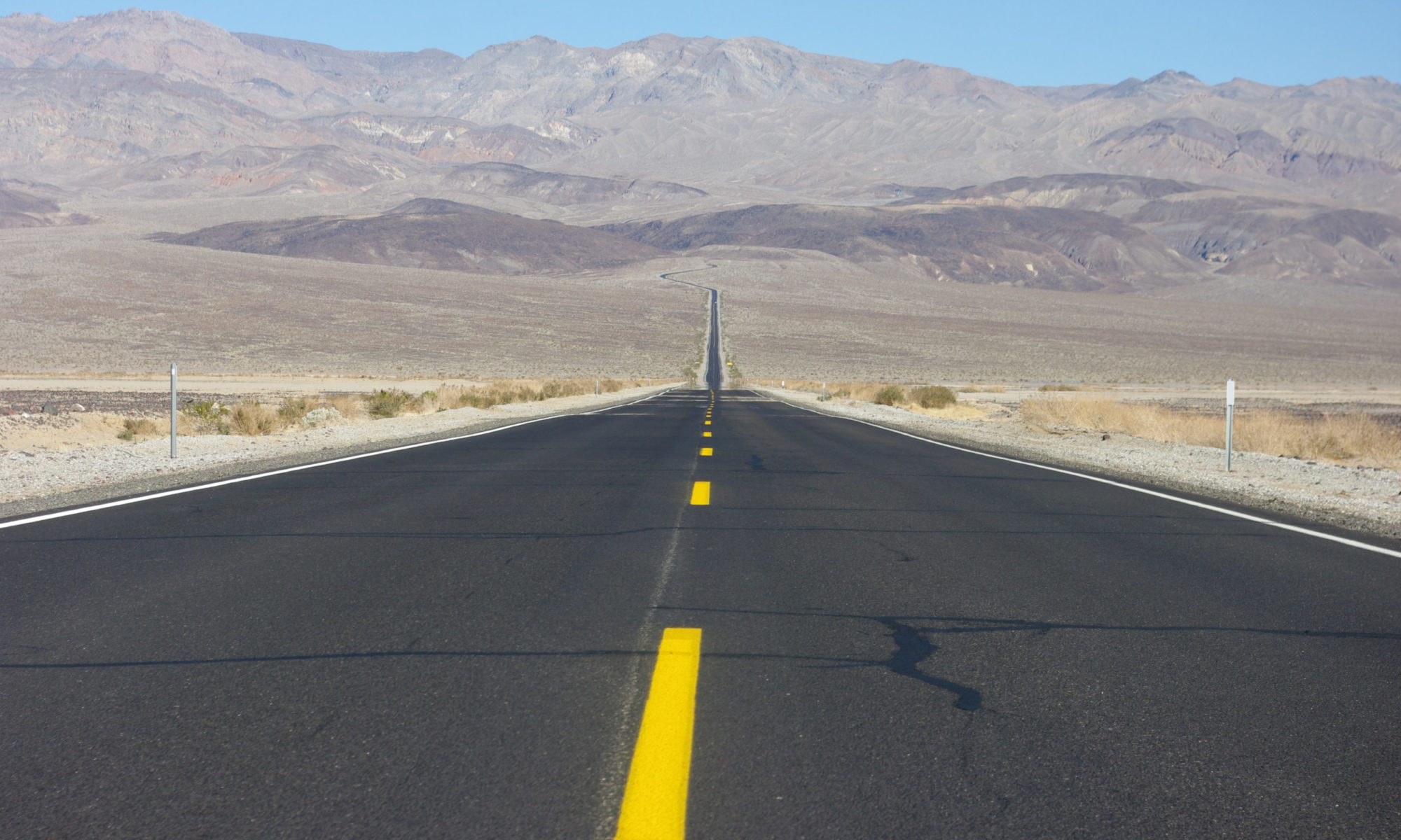
In canyon country, we force our bodies through cracks in the ground in places like Buckskin Gulch and Grand Staircase Escalante National Monument, send the Bobs down tough roads, and struggle with some big questions about land use. After 35 days of this, after enjoying endless canyons, gorgeous dispersed camping spots, carefully timed resupply runs, and achieving furnace temperature perfection, we finally feel like we have hit our stride with road life – just in time to pause for a few weeks.
This episode was written, recorded, sound edited, and produced by Lisa McNamara, with additional recording and editing by Paul Olson. Music by Michael Kobrin from Pixabay.
Subscribe:
Photos from this episode: visit our blog, Driving Inertia
Transcript:
This is Road Tripping in America, a podcast about life on the road. I’m Lisa and this is Paul.
We’re exploring the US in a pickup truck with a camper – we named our setup The Bobs.
If you daydream about long-term travel or overlanding or vanlife – or maybe you’re already on your own adventure – join us for some entertainment from the road. We’re in search of off-the-beaten-path adventures and new experiences after a year and a half of standing still.
(music)
Today: endless canyons, gorgeous dispersed camping spots, carefully timed resupply runs, furnace temperature perfection – we finally feel like we have hit our stride with road life, just in time to pause for a few weeks.
This is series two, episode nine: 35 Days in Canyon Country.
This episode was recorded in Durango, CO.
(music)
It’s day 34 of our 35 days in canyon country and I’m feeling bittersweet. I have that old ‘end of vacation’ feeling. We’re camped at a beautiful dispersed campsite on the rim of Rock Creek Canyon, in Canyons of the Ancients National Monument northwest of Cortez, CO, reminiscing on our past few weeks of canyon country exploration.
Paul pours some whiskey (whiskey pouring sound), I crack open a beer (beer sound), and we try to come to terms with this feeling.
Paul: What did you want to talk about?
Lisa: I wanted to talk about the fact that it feels like the end of our trip, even though it isn’t! It feels like the end.
Paul: Oh yeah, the end of phase one.
Lisa: But I’m really sad about it. To me it feels like an end that I’m not ready for.
Paul: Well, yeah, partially because all the family obligations coming up.
Lisa: (scoffs) That’s the good thing!
Paul: (in a happy voice) Because of all the family obligations coming up!
Lisa: Well, yeah, because it means that we’re going from 100% controlling our time to…less than that.
Paul: Less than that. I think too, it’s tough because the summer’s coming to an end and we’ve been freezing – I mean, it’s definitely done.
Lisa: The summer’s over!
Paul: Yeah, it’s definitely the fall.
Lisa: Yeah, hard to accept it.
Paul: So it’s very obvious that the year is starting to wrap up and I don’t know if we always felt that – or if I always felt that until maybe a little later. It also means – it’s like we’re moving out of our place too, we’re not going to be making dinners in here, making coffee.
Lisa: Right! Not sleeping in here.
Paul: So it’s the end of that for awhile too.
Lisa: Yeah, I’m kinda bummed! And it feels like it snuck up on me, all of the sudden.
Paul: Even though it was extra time!
I had been waiting for the canyon country part of our trip since we started, back in June. I have had things on my canyon country to-do list queued up for years. Things I had read about, things we didn’t have enough time to do or do well in the past, things we had been rained out of before. And now it was done and we were returning to the world of indoors living for a couple months. But at the same time, we needed a break. Things were getting legit funky smelling in the Bobs. Fresh fruits and veggies had become few and far between. Nights were getting very cold. Frosts were covering the Bobs in the morning. We needed a break. But wow – was it a great 35 days.
On day -5 of 35, I had started seriously planning our canyon country itinerary. Usually we do some combination of Paul planning while I drive, both of us planning, or just winging it. This time, I was in charge of planning our month in canyon country, because – that list of things that I had. So, a couple days before we returned to Las Vegas, while we had great internet access, I roughly planned out our route.
I had first visited Utah and Arizona as a kid and could not believe that places like these existed. All the red rock, the funny boulders, the arches, the canyons making deep cracks in the earth, the colorful mud, the stars at night that were ten times brighter than the stars at home, even though I grew up in the middle of the woods with no major cities for miles. I was hooked.
So now, starting in early October, we’d head east from Las Vegas, roughly across southern Utah and northern Arizona, stretching out the stops along the way as long as we wanted, before making it back to Fort Collins just before Thanksgiving to see familiar faces and pick up our winter gear from storage, then we’d celebrate Thanksgiving with family near Denver. Major highlights along the way, the must-dos, were places like Buckskin Gulch, Grand Staircase Escalante National Monument, Lake Powell, State Parks in Nevada and Utah. The popular, easily accessible parts of the big five national parks were NOT on our list – we had luckily seen them on past trips and had heard they’re now much too busy for our liking. We would stick to the more remote places this time – the dirt roads, the places that take longer than a day to get to, the places the locals go.
I love this part of the country so much because it still feels so wild. The dirt roads in UT, NV, NM, and AZ are a modern explorer’s paradise. When it feels like so much of the world has already been explored, that there’s nothing new to find, you can still see this area as the first explorers saw it, as the native people who lived on the land saw it. Very, very few places like that still exist.
Out there on the dirt roads in canyon country, there aren’t any road signs, trails aren’t marked, hell, trailheads aren’t even marked. The road ends and you think there’s a trail there, so you search for signs of footprints leading off in some direction that feels right. You stop at every turn in the road to scout out the spurs, see if they go through to another road or dead end. You scout out wash crossings and figure out the best way across, which sometimes means finally using the knockoff Maxtrax you’ve been carrying around for five months and other times means turning around and going back the way you came. You fill up on water and gas and food and head out down a dirt road, never minding that you’re not going to get a shower for seven days, that you will run out of wine, that the fresh food will be eaten within the first few days, that you won’t see another person, except for a distant car or two, for days. Never minding that you will have sand between your toes 100% of the time. Knowing that you’re responsible for rescuing yourself if something goes wrong and if you fail, you fail with consequence.
Along the way, I knew we’d face some tough stretches where things like groceries, showers, and internet access would be few and far between. But I wasn’t expecting it to get so cold, so fast. Or rain so much.
On day 2 of 35, we woke up to a sprinkle of rain on the roof. Later that day, we had to hurriedly leave our campsite, because the road to the site was a wash and it was about to pour and we didn’t want to risk getting stuck or stranded. And thus started our month of dodging the rain.
On day 5 of 35, I realized we wouldn’t be able to do everything I wanted to do, even though it felt like we had so much time. Things other than time were going to constrain us. On that day, we sat in a hotel and watched the rain fall in Hurricane, UT, where the trees were still green, after we had driven an entire day in the rain and found that the road to the area where we’d been planning to camp was currently a river, in an area where it’s extremely unusual to drive an entire day in the rain.
This year, it felt like there was no shoulder season in the west. In one weekend, it went from scorching, 100 degree plus days to cold, cold, cold and the start of what would end up being record levels of rain and snow. October in Utah saw an unusually large amount of rain. Which is good, right. But when you’re planning to crawl around in every slot canyon you can find from west to east across the state, that extra rain presents some challenges.
After that first unexpected and expensive hotel night in Hurricane, we got much better at actually looking at the weather forecast and booking hotels in advance when it was expected to rain, snow, and gust, which it did on what felt like a weekly basis after that first hotel night.
On day 14 of 35, I finally accepted the inevitable and bought a pile of warm clothing in Page, AZ. Warm things to sleep in, fleece lined tights for layering under other pants, wool socks, gloves to wear to bed. Gloves to wear to bed! We figured out the best times and temps for operating Bob the camper’s furnace – the furnace that I hadn’t been sure we even needed. Boy, did we need it. We learned early on that we couldn’t set the thermostat to a normal house level overnight, say to 68 degrees, because the blower would kick on and off constantly and the bed area, a few feet above the thermostat, would become uncomfortably warm.
After testing out a few temps, we found that setting the heater at 47 degrees overnight was the right balance between it kicking on so often that it woke us up and us waking up because we’re freezing. When we were camping in our minivan, we stayed far enough south so that our nightly low temps never went below 50 or 55 degrees, because we didn’t have supplemental heat (and weren’t going to run the van’s engine at night). That was easy to do – big stretches of the country qualify, from southern AZ and CA, to southern TX (NM and western TX are higher elevation and too cold), to any of the Gulf states.
Now, we can stretch that comfort range much further. And since we didn’t want to get too far from our CO Thanksgiving destination, we would bundle up and stick with our planned route through Utah rather than veer farther south. But we were regularly getting into the upper 20s or mid-30s at night. And that was cold.
So we were nested up in a pile of blankets, we were sleeping in hats and gloves and insulated turtlenecks and long johns and wool socks and it was chilly but it was OK. We moved slowly in the mornings, waiting for the frost and condensation to be sucked back into the dry desert air.
But never mind that, the cold was tolerable because it was glorious during the day. In this strange mix of fall and spring, where the cottonwoods were a vibrant yellow while the shrubs glowed green and smaller plants and grasses took the opportunity to send up new shoots thanks to the rains, where we got hard frosts multiple nights and sweaty and sunburned during the days, as soon as the sun came up, it was perfect hiking weather.
(sound)
I could talk for hours about canyon country, long past when anyone listening has glazed over with boredom, so I’m trying to focus here. The main places that I want to talk about are Buckskin Gulch and Grand Staircase Escalante National Monument.
Naturally, Edward Abbey was the source for many of the canyons on my ‘explore someday’ list. I would read his books and pause constantly to note down the names of interesting sounding places, which ended up being basically any place he mentioned. Today, many places still seem to be the same as when he rambled around the desert decades ago, but others have become National Park-level famous and busy and places he would have hated. Of course I prefer the former too. I also subscribe to the idea that I would rather enjoy natural places with few to no others enjoying them with me at the same time.
We used the Bobs to get close to the more remote places and the bikes to travel the last miles to the trailheads when those miles were especially rough. In the places where we put in this much effort, we always had them to ourselves. But other places that were difficult to get to, like Buckskin Gulch, were still busy. When a place has been written about as a must-visit, bucket list type thing, people will do all kinds of questionable things to visit. If there’s a deep muddy water crossing on the road, they’ll leave their 2 wheel drive sedan on one side of the crossing and catch a ride with a stranger in a high clearance, 4WD vehicle the rest of the way to the trailhead. They’ll pile in the back of a pickup truck for a teeth-rattling ride down a bumpy road to avoid hiking 10 miles round trip.
And it’s true that there’s only one longest and deepest slot canyon, but what people don’t realize is that there are hundreds of other slot canyons out there – they could spread out a little bit. Or not. That’s something we debate often – is it better to have the tourists crowd places like Arches National Park, so the hundreds of other arches across canyon country are free for solitary exploration? Is it better that Buckskin Gulch has become National Park-level famous so those unprepared and unfamiliar hikers will concentrate themselves and future rescue operations in one place rather than spreading out across the desert? Like Glen Canyon instead of Dinosaur National Monument for Lake Powell – should we keep the flood of people and water to one or two places so the others can remain wild?
If you’ve been to a place like Buckskin Gulch or Spooky and Peekaboo Gulches or Corona Arch or even Arches National Park within the last couple years, you’ll know what I mean by National Park-level famous. National Park famous can be diagnosed by the waves of obviously inexperienced and under-prepared hikers leaving the trailhead in the late afternoon for a hike that takes hours round trip; hikers without any water on a desert hike; multiple kids running around off trail with no parental control; unleashed dogs bounding all over a steep slickrock slope that other hikers are trying to scramble without losing their footing; people who can’t follow an unmarked trail, down a riverbed, no less; people who don’t know any trail etiquette or who just don’t care. All of which we encountered in Buckskin Gulch.
I can’t figure out how Buckskin Gulch became National Park-level famous, other than the fact that it is the longest and deepest slot canyon in the American West. (The slot portion itself is 13 miles long.) The trail starts at the same trailhead as the Wave, which is tightly controlled and restricted and very famous. If people can’t get a Wave permit, do they figure that Buckskin is the next best option? Back in 2008, it was written up as one of the most dangerous hikes in America by Backpacker Magazine, but the National Park famous crowd doesn’t look like danger would be the draw for them. The LA times in June wrote Buckskin up as one of the best hikes in the country, but the author was also unsparing about the difficulty and sometimes unpleasantness of it.
There are four main trailheads for accessing Buckskin Gulch, all involving fairly long and difficult hikes. Day use permits are required, and while they are unlimited, they are now online-purchase only in an area with patchy cell service. Luckily we started at the entry point closest to civilization so were able to purchase passes for all areas before we went deeper into the wilderness. Easily tracking who is in this dangerous place in case of an emergency makes sense, but we were left to wonder if the future of hiking is like Tock for fine dining? Will we at some point always be required to buy tickets in advance for entry to natural places like we’re going to a concert or searching for a vaccine appointment?
So Buckskin was busy, yes. It was bureaucratic. It was very wet. It was very muddy. The mud had the consistency and texture of peanut butter and made the sound you can imagine peanut butter would make if walked upon.
(footsteps in Buckskin)
There were deep pools of icy water and of quicksand – that’s right, I finally saw and accidentally stepped in real quicksand and let me tell you, it was terrifying. But I’m so happy we had a chance to experience Buckskin. Because we got on the trail early and spent three whole days checking out the different routes, we often had large stretches of canyon completely to ourselves. The walls are that high and the canyon is that narrow and it really does feel never ending. If you have to turn around before the end then – it is never ending for you. And that’s what it will be for me until and if I finally make a through-hike happen.
(sound)
After the busy depths of Buckskin, the even more remote and less popular slot canyons of Grand Staircase Escalante National Monument were a welcome treat.
Before we go too far, I just need to let you know that I can’t say Grand Staircase Escalante National Monument every single time I talk about the place. The typical abbreviation is the acronym, GSENM, but I find that even more difficult to say. So I’m going to call the National Monument just Escalante from now on, and if I’m referring to the town of Escalante I’ll call it Escalante town, and hopefully things won’t get too confusing.
Back on day 5 of our 35 days in canyon country, while we were trying to stay dry and, yes, eating Domino’s Pizza in our Hurricane hotel room, a few days before Indigenous Peoples’ Day, the Biden Administration announced the restoration of Escalante to its pre-2017 boundaries.
The monument was established in 1996 at 1.7 million acres, grew to almost 1.9 million acres, but then was reduced by half in 2017. While the reduced areas had still been afforded some protection, they had reverted to basically the lowest level of land protection and oil and gas drilling, coal mining, and livestock grazing leases were planned to be sold on large parts of the downsized monument land. Restrictions were removed on areas designated to protect ancestral Puebloan sites.
National Monument protection is still a lighter level of protection than a National Park designation, but it prohibits things like drilling, resource extraction, dam construction (like I mentioned in the Dinosaur episode), grazing. So it is a huge deal to get these protections back in place before any irreversible damage was done. Still, a future administration with different opinions could shrink things down again. The fight is never over – unless the area becomes a National Park, which would make it National Park-level famous, and…there’s no perfect answer.
Escalante was the last place in the lower 48 states to be mapped. Much of it is still very undeveloped, most of the access roads are dirt, and many roads require 4WD. It’s perfect. The first time we visited, we spent something like $500 to rent an ancient, rattly old Jeep for 24 hours, because at the time we only had a tiny Honda Fit. But this time, we were able to cover all the ground we wanted to cover with the Bobs, or with the bikes for the last mile. I can’t even count the number of days we said some variation of, “we can always turn around if it gets really bad,” before starting down a sketchy-looking dirt road. There’d be some sort of gatekeeper – a deep, wet wash, a tough climb, but we took it slow and we always made it through.
Thanks to the undeveloped and unmarked trails, we were usually the only people we saw in a day. We had miles of canyons and slots to ourselves. We spent eleven nights dispersed camping in Escalante, sometimes with views of Bryce Canyon to the west, sometimes overlooking the Hole in the Rock road valley, once at a place we named 39er canyon last year, when we were there during the five days we’re both the same age every year.
Across 35 days in canyon country, we crawled around in 26 different canyons – sometimes exploring three in a day, sometimes spending three days in the same one. Why do I love slot canyons so much? Often they’re an exercise in defeat and discomfort. Often we are forced to turn around before the “end” of a slot canyon because it’s full of cold, stinky water or there is an insurmountable dryfall that we can’t climb. By the way, a dryfall is what would be a waterfall if there was running water – it’s a smooth or undercut steep, rocky dropoff surrounded by high walls that requires more of an advanced canyoneering skill and mindset than we have to tackle.
It’s strangely comforting and peaceful to me to wedge myself into a little crevice in the ground created by violently rushing water. Turning around in the middle of a slot canyon, it’s the same thing as accepting the inevitability of death. I’m not going to be ready for it to end, but it’s going to happen whether I’m ready or not, so I might as well enjoy the time I’m there. It definitely teaches you to be in the moment.
What is it about forcing myself through cracks in the ground that is so appealing? It’s a little bit of the danger, sure. It’s the rock, and the patterns, and the color of the light as it filters down – orange and warm up top, blue and cool down below. It’s also like traveling back through time to walk through ancient rock layers. In one spot in Escalante, I came across a petrified tree that was standing upright along the wash in a hillside made of volcanic ash that was slowly being carved out by the river’s flow. I could stand next to a petrified tree, standing as it was when it had been buried in that ash an inconceivably long time ago. I could see the bark still on the tree, what looked like lichen on the bark, the best and most intact example of petrified wood I’ve ever seen. Nearby, another petrified tree had fully eroded out of the cliff and smashed into many pieces on the ground and I could imagine more trees like these, standing as they were when they were buried by a sudden eruption, stretching back into the hillside before me. There are fossils like this too, and dinosaur tracks. Canyon country just dares you to notice the ancientness of our earth and all the things that have gone before us.
But if you need more than canyons, Escalante has that, too. Highway 12 from Escalante town to Boulder, UT (which some maps actually label as Boulder Town) is one of the most gorgeous and terrifying paved stretches of road I’ve ever driven. No matter how many times you drive it, it’s still awe-inspiring. Off this stretch of road is probably the most popular hike in the Monument, Lower Calf Creek Falls. Even though it can get really busy, I’d still highly recommend it because it’s a gorgeous hike through a wide canyon back to a good sized waterfall, which is a rarity in the desert. Just get out there early.
Between the two towns of Escalante and Boulder you can also find arguably the best coffee shop in the west – Kiva Koffehouse. It’s closed now for the season, but we made it in on one of the last days they were open and enjoyed a coffee and slice of quiche while looking over the Escalante River valley, which was filled with a river of yellow cottonwoods. Also closed for the season currently, but worth planning to visit, are the Hell’s Backbone Grill and the Burr Trail Grill and coffee shop in Boulder. Year after year, these two amazing places have been here, serving delicious food in this restaurant oasis.
And for non-canyon hikes, there’s the strenuous but beautiful Boulder Mail Trail, which connects the towns of Escalante and Boulder via a 15 mile-long trail, which, in fairness, starts in a canyon. The mail trail was formalized in 1902 and used until 1940 to carry mail and other items from Escalante town to Boulder, through a landscape that was (and still is) incredibly daunting. An informational sign on the Escalante town side mentions that the trail was also used by young men hurrying to a dance in one of the other towns. This is a really entertaining thing to picture as you scramble up and down the extremely steep slickrock hills. I hope they all sobered up before trying to get back home.
On day 23 of 35 we started seriously talking about moving to Escalante town. We realized that this town is the secret western Colorado town we had been trying to find earlier this summer. It has all the criteria – except for the Colorado part. Before the pandemic shutdowns, I thought of this area as much too remote and isolated to consider living there permanently, but now, it’s really appealing. To have a slice of this incredible area, to see snow dusting the nearby mountaintops, to drive down all the roads, to have the canyons to ourselves when the tourists go home. Can we live somewhere where we’d need to drive over four hours to get to an international airport? Where we’d need to drive to another state to get good wine? Maybe?
On day 35, we rolled into Durango, CO, where we would be staying for two weeks, taking a break from the cold and catching up on life maintenance chores. That morning, we organized the Bobs and packed up most of their contents to bring into the rental. While I will miss camping out in the Bobs for the next couple months, I’m excited to take a break from the constant motion, to be in one place for longer than a day or two again. To see family and friends. But I know the road will be calling again, and soon. Back in Utah, the wind and the rain will erase us. Little by little, they’ll move the grains of sand that formed our footprints and tire tracks until there’s no trace left. And so we’ll need to get back there again before too long.
(music)
Next time: six months on the road wrap-up. From budget to unanswered questions from previous episodes to corrections – we’ll cover it all.
Until then, check out our website, roadtrippinginamerica.com for a transcript and photos from this episode. If you are enjoying this podcast on Apple Podcasts, please leave us a review or rating – that can help others find the podcast.
Thanks for listening! And Happy Thanksgiving, however you choose to celebrate.
(blooper)